GEOTECHNICAL ENGINEERING1
ASHFORD
HomeSeismicSeismic microzonation

Seismic Microzonation Studies in Ashford: Reading the Ground Before It Moves

Knowledgeable. Thorough. Resourceful.

LEARN MORE

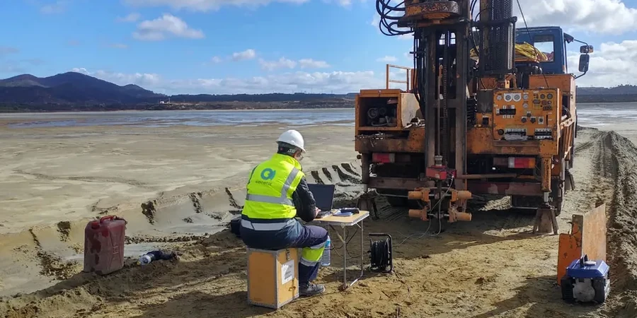
Ashford’s expansion from a medieval market town into a major rail hub and growth corridor has placed new demands on its underlying geology. The ground beneath the borough shifts from the stiff Weald Clay to pockets of river terrace gravels and softer alluvium along the Great Stour, and each material responds differently when seismic waves travel through it. In our experience, the 2007 Folkestone earthquake, though modest at magnitude 4.3, was felt distinctly in parts of Ashford and reminded engineers that the UK is not aseismic. A proper seismic microzonation study maps these contrasts across a site, giving structural designers something far more useful than a single blanket value. When we combine this with MASW surveys to capture Vs profiles down to 30 metres, the picture of how the ground will actually shake becomes clear enough to act on.

Ashford sits on a patchwork of stiff clay, gravel terraces and alluvium: a single site class for the whole plot is rarely the right answer.

Our service areas

Scope of work

A recurring mistake we see in Ashford is applying a generic site class from a desk study without verifying the shear-wave velocity of the weathered clay crust. The upper two to five metres of Weald Clay are often softened and fissured, and that weathered zone can amplify ground motion in ways a deeper borehole log alone would miss. BS EN 1998-1 (Eurocode 8) requires site classification based on Vs30, and the difference between a Class C and a Class E designation can double the design spectral acceleration. A proper microzonation programme ties CPT testing to surface-wave geophysics so that the stiffness profile is constrained at multiple points, rather than extrapolated from a single measurement. The result is a map that shows not just one number but the spatial variation that matters for larger footprints and masterplans.
Seismic Microzonation Studies in Ashford: Reading the Ground Before It Moves
Technical reference — Ashford

Area-specific notes

BS EN 1998-5 and the UK National Annex provide the framework, but in Ashford the real challenge is the lateral transition between the Hythe Beds, the Atherfield Clay and the alluvial corridor of the East Stour. A structure founded partly on gravel and partly on soft clay can experience differential ground motion even during a moderate event, concentrating stress at the interface. The British Geological Survey’s 1:50,000 sheet for Ashford shows these boundaries clearly, but the resolution is too coarse for foundation design. Site-specific microzonation reduces the risk of underestimating short-period amplification, which matters most for low-rise masonry and mid-rise concrete frames. The cost of getting the site class wrong shows up first in the reinforcement detailing, and later, if the ground moves, in the cracking pattern.

Need a geotechnical assessment?

Reply within 24h.

Email: contact@geotechnical-engineering1.com

Standards used


BS EN 1998-1:2004+A1:2013 (Eurocode 8 – General rules, seismic actions), BS EN 1998-5:2004 (Eurocode 8 – Foundations, retaining structures), BS 5930:2015+A1:2020 (Code of practice for ground investigations)

Typical values

ParameterTypical value
Vs30 target depth30 m below ground level (per BS EN 1998-1)
Site classification outputGround types B to E, with sub-class boundaries mapped
Typical Vs range, Weald Clay250–450 m/s depending on weathering grade
Typical Vs range, river gravels200–350 m/s, often underlain by stiffer clay
Amplification factor (Fa, Fv)Computed per UK National Annex to BS EN 1998-1
Seismic hazard referenceBGS seismic hazard maps, Eurocode 8 PGA contours
Reporting formatColour-contoured site map with VS profiles and design spectra

Frequently asked questions


Is seismic microzonation really necessary for a project in Ashford, given the UK’s low seismicity?

Yes, for certain structures. BS EN 1998-1 applies to safety-critical and high-consequence buildings regardless of perceived hazard, and Ashford’s complex shallow geology means site amplification can vary significantly over short distances. A microzonation study provides the site-specific data that allows the design team to optimise the structural solution rather than defaulting to conservative assumptions.

How long does a typical microzonation survey take for a medium-sized site in Ashford?

Fieldwork for a combined MASW and CPT campaign on a site of about one hectare usually takes two to three days. Processing, inversion modelling and preparation of the contoured maps and design spectra typically require an additional two weeks, depending on the complexity of the ground profile.

What is the typical cost range for a seismic microzonation study in Ashford?

For a site-specific study combining geophysical lines and CPT calibration, the cost in the Ashford area generally falls between £3,540 and £14,620, depending on the number of measurement points, the depth of investigation and the level of reporting required by the design team.

Can microzonation results be used to reduce foundation costs?

Often yes. When the site investigation demonstrates a stiffer ground type than a conservative desk-study assumption, the design spectral acceleration can be reduced, which may allow lighter reinforcement, smaller foundation elements or a more economical structural frame while remaining fully compliant with BS EN 1998.

Location and service area

We serve projects across Ashford and surrounding areas.

View larger map