GEOTECHNICAL ENGINEERING1
ASHFORD
HomeInvestigationExploratory test pit

Exploratory Test Pits in Ashford — Fast Stratigraphy Verification Before Construction

Knowledgeable. Thorough. Resourceful.

LEARN MORE

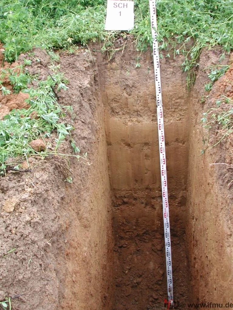
Too many groundworkers in Ashford start a dig and hit a soft clay lens or a chalk seam that wasn't on the geological map. That five-minute surprise turns into a two-day delay, a phone call to the structural engineer, and a budget headache. We run exploratory test pits before the machine bucket even touches the ground. Our crew opens a trench, the engineer logs the profile, photographs the strata, and takes bulk and undisturbed samples straight from the face. You get a clear answer on bearing strata, groundwater depth, and any fill that shouldn't be there—all on the same day. The process follows BS 5930 and Eurocode 7 guidelines, and the report includes field descriptions, in-situ density checks, and lab scheduling if needed. When the soil profile is complex or the site sits near the Stour river terrace, combining the pit with an in-situ permeability test can clarify drainage assumptions before foundation design is locked in.

A 3-metre trench tells you more about Ashford's chalk and clay in 45 minutes than five boreholes can in two days—because you see the strata, not just the spoil.

Our service areas

Scope of work

Ashford sits on a patchwork of Cretaceous Lower Chalk, Gault Clay, and Quaternary river gravels. The Folkestone Beds outcrop to the south, while the town centre overlies Weald Clay with sand lenses that can channel groundwater unpredictably. We open exploratory test pits across the site to map exactly where these transitions occur. Depths typically run 3.0 to 4.5 metres, depending on the chalk head or the water table—which in wet winters can rise to just 1.2 metres below ground level near the East Stour. Each pit gets a systematic log: colour, consistency, moisture, estimated strength with a pocket penetrometer, and any signs of oxidation or root disturbance. If the strata show interbedded soft clays, we recommend pairing the pit data with grain-size analysis to quantify fines content and refine the drainage design.
Exploratory Test Pits in Ashford — Fast Stratigraphy Verification Before Construction
Technical reference — Ashford

Area-specific notes

Sites near Singleton and Great Chart sit on thick gravel terraces—drainage is rarely an issue, and the bearing is decent. Move half a mile north toward South Willesborough, and the profile changes to soft alluvial clays with peat traces. That difference is why we never extrapolate a neighbour's ground report. An exploratory test pit on a Willesborough site once revealed a buried backfilled pond at 2.2 metres depth—undocumented, invisible from the surface, and fatal for a shallow footing. In the town centre, we often encounter old cellars and brick rubble fill from post-war reconstruction. A pit exposes these hazards before they become a piling change-order. The risk is not the pit cost—it is the foundation redesign cost that hits when nobody looked.

Need a geotechnical assessment?

Reply within 24h.

Email: contact@geotechnical-engineering1.com

Standards used


BS 5930:2015 — Code of practice for ground investigations, Eurocode 7 (BS EN 1997-1:2004) — Geotechnical design, BS 1377-9:1990 — In-situ density tests

Typical values

ParameterTypical value
Maximum depth (standard machine)4.5 m
Typical trench length2.0 – 3.5 m
Logging standardBS 5930:2015
Sample types recoveredBulk disturbed, block undisturbed, bag samples
In-situ density methodSand replacement or core cutter (BS 1377-9)
Groundwater observationStrike depth and 24-hr rebound where possible
Report deliveryDraft log within 24 hours, final report within 3 working days

Frequently asked questions


How much does an exploratory test pit cost in Ashford?

A standard exploratory test pit in the Ashford area typically ranges from £340 to £600, depending on depth, number of pits, access constraints, and whether lab testing is required on the same day. The price includes the excavator, operator, full engineering log, photographs, and a factual report. If you need multiple pits or combined services like in-situ density testing, we provide a fixed quote after a site walkover.

How deep can you go with a test pit in Ashford's chalk?

In the chalk and weathered chalk head common around Ashford, we routinely reach 3.5 to 4.5 metres with a standard backhoe excavator. Beyond that depth, chalk can become blocky and the trench stability becomes a safety concern. For deeper investigation into bedrock, we recommend switching to SPT drilling or rotary coring.

Do I need a test pit if I already have a borehole log?

Boreholes give you a vertical profile at a single point. A test pit gives you a continuous exposed face—you see lateral variation, fissures, and buried features that a borehole can miss. In Ashford's variable drift deposits, we often find that one pit reveals more about the near-surface conditions than two boreholes.

How quickly do you deliver the report after excavation?

We issue a draft field log with photographs within 24 hours of completing the pit. The final factual report, including lab test results if samples were taken, is typically delivered within three working days. For urgent projects, we can prioritise the final report to meet a next-day deadline.

Location and service area

We serve projects across Ashford and surrounding areas.

View larger map