GEOTECHNICAL ENGINEERING1
ASHFORD
HomeGeophysicsSeismic tomography (refraction/reflection)

Seismic Tomography (Refraction/Reflection) in Ashford

Knowledgeable. Thorough. Resourceful.

LEARN MORE

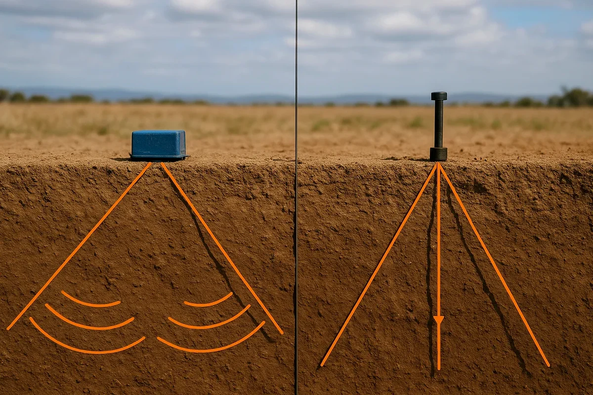
A 24-channel seismograph with 4.5 Hz vertical geophones gets laid out across the site. Spacing runs 2 to 5 metres depending on target depth. The sledgehammer and plate source hits clean on compact gravels near the Stour, but the marsh-edge clays south of the M20 need a weight drop. We shoot multiple stacks per shotpoint. The first-break picks for refraction give us P-wave velocity profiles down to 30 metres. Reflection processing pulls deeper horizons when the chalk bedrock drops below 60 metres. For sites where soil stiffness governs foundation design, we pair the seismic survey with MASW to extract Vs30 profiles in one deployment. On brownfield plots with uncertain fill history, a resistivity line helps separate made ground from natural strata before tomographic inversion.

P-wave velocity in saturated Gault Clay runs 1450–1650 m/s. Chalk bedrock jumps to 2100+ m/s. The contrast is unmistakable on a tomogram.

Our service areas

Scope of work

BS EN 1997-2 Section 4.2 and BS 5930:2015+A1:2020 set the framework for geophysical investigation in the UK. In Ashford the relevance is direct. The Hythe Beds and Sandgate Formation create sharp velocity contrasts that refraction handles well; the Gault Clay beneath demands reflection to map the chalk interface. We run tomographic inversion with 12 to 24 geophone channels. Ray coverage is dense through the upper 15 metres, which is where most foundation decisions sit. Velocity models are calibrated against one borehole or trial pit minimum, often tied to an SPT drilling log for N-value correlation. The output is a 2D P-wave tomogram with RMS error below 5%. We supply SEG-Y raw data, DXF interpreted horizons, and a technical note with rippability classification per BS 5930 Annex B. Turnaround for a 150-metre line with interpretation is three working days.
Seismic Tomography (Refraction/Reflection) in Ashford
Technical reference — Ashford

Area-specific notes

Ashford's expansion since the 1990s—first as a rail hub, then as a growth area under the Kent Structure Plan—pushed development onto the Weald Clay vale and the Romney Marsh margins. The Marsh in particular hides buried channels and compressible peats beneath a metre of desiccated crust. A borehole every 25 metres misses lateral variation. Seismic tomography fills the gaps. A 2D velocity section flags low-velocity zones that correlate with soft alluvium or peat lenses. Miss those, and differential settlement appears within the first two years. The Joint Venture on the Ashford Ring Road upgrades demonstrated exactly this: pre-construction seismic lines altered the retaining wall alignment in three locations. Deep excavations near the International Station also benefit from reflection data that confirms chalk competency before piling design commences.

Need a geotechnical assessment?

Reply within 24h.

Email: contact@geotechnical-engineering1.com

Standards used


BS 5930:2015+A1:2020 – Code of practice for ground investigations, BS EN 1997-2:2007 (Eurocode 7) – Ground investigation and testing, BS 1377 – Standard guide for seismic refraction, BS EN ISO 22475-1:2021 – Sampling and groundwater measurement, CIRIA C812 – Good practice guide for geophysical surveying

Typical values

ParameterTypical value
Seismograph channels24 (Geode or equivalent)
Geophone frequency4.5 Hz vertical component
Source typeSledgehammer + plate; weight drop for soft ground
Typical spread length46–115 m (refraction), 120–240 m (reflection)
Depth penetrationRefraction to 30 m; reflection resolves chalk at 60+ m
Sampling interval0.125–0.250 ms
Record length1.0–2.0 s
DeliverablesSEG-Y, DXF horizons, PDF tomogram, interpretive note

Frequently asked questions


How much does a seismic refraction survey cost in Ashford?

A single refraction line of 100–150 metres with 24-channel acquisition and tomographic processing typically ranges from £2,200 to £4,700. The final figure depends on line length, number of spreads, source type required, and whether reflection or MASW is added.

What depth can refraction tomography reach in the Ashford area?

With a 115-metre spread and a weight drop source, we routinely image to 25–30 metres below ground level on the Hythe Beds and Sandgate Formation. Where Gault Clay is thick, refraction penetration drops to 15–20 metres; we then switch to reflection to map the chalk at 40–70 metres.

How do you calibrate the velocity model?

The reference range for this service in Ashford is £2.200 - £4.700. The final price depends on the project scope and volume.

Location and service area

We serve projects across Ashford and surrounding areas.

View larger map